 copyright,
Kellscraft Studio copyright,
Kellscraft Studio |
Click Here to return to Boston Illustrated Content Page Click Here to return to Previous Chapter |
 (HOME) |
|
copyright,
Kellscraft Studio |
Click Here to return to Boston Illustrated Content Page Click Here to return to Previous Chapter |
(HOME) |
|
VI. THE HARBOR.
BOSTON HARBOR is protected by the natural breakwater on which stands the town of Hull. This is a singular peninsula, jutting northward from the South Shore, and partially enclosing an extensive body of water. Hull has several points of interest. Nantasket Beach, on the side of the peninsula towards the sea, is one of the finest on the coast, and it has become a favorite and very popular place of resort in the summer. The summer population is largest at the lower or southern end of the peninsula, while the permanent population is mostly concentrated near the other extremity. On the high hill, which overlooks the entire entrance to Boston Harbor, is situated the observatory, from which the arrival of vessels, their names, and the point whence they come, are telegraphed immediately to the Chamber of Commerce in the city. Hull is one of the smallest towns in Massachusetts, and there have been many jokes at its expense on this account. The vote of the town is almost always one of the first returned at a general election. From this there has arisen the curious saying, “As goes Hull, so goes the State,” — a saying which is very far from true. Dr. Holmes said in his “Autocrat of the Breakfast-Table,” that in this town they read a famous line with a mispronunciation pardonable under the circumstances, —“All are but parts of one stupendous Hull.” The harbor of Boston is filled with islands, most of which have a history that it would be exceedingly interesting to recount. That of Castle Island, on which Fort Independence now stands, is more prominent in Colonial and Revolutionary annals than any other, both because it was the first island fortified and because it was so accessible from the town. This island was the scene of many a fatal duel in the olden time. Thompson’s Island is remarkable for its fantastic shape, which has been likened to that of an unfledged chicken, and also for the numerous and protracted controversies that have taken place to settle the ownership of the island in the early days of the colony. Spectacle Island, so named from its form, was formerly used for quarantine purposes, but is now given up to the business of converting retired car horses into a variety of useful products. Most of the islands were granted by the General Court, during the first years of the settlement of Boston, to persons who agreed to pay a yearly rental in shillings or rum for their use. Ultimately they became private property either by compounding for the yearly rent or by a sort of preemption which was accomplished without the aid of any other law than that of possession. 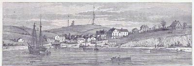 View of Hull. Numerous steamboats ply between the city and the places of resort in the harbor and just outside of it. For reasonable fees one may steam in and out between the several islands, and enjoy, on the most sultry of days, a cool and refreshing breeze, together with the most delightful and ever-changing scenery. Among a great many points of interest along the trip down the harbor, only a very few can be here mentioned. The first fort built upon Castle Island was constructed in 1634, and since that time the island has always been fortified. The works have been rebuilt a great many times. Castle William stood on this island when the Revolutionary war broke out, and when the British troops were obliged to evacuate Boston they destroyed the fort and burned it to ashes. The Provincial forces then took possession of the island, and restored the fort. In 1797 its name was formally changed to Fort Independence, — the President, John Adams, being present on the occasion. In 1798 the island was ceded to the United States. From 1785 until 1805 this fort was the place appointed for the confinement of prisoners sentenced to hard labor, provision having been made in the act of cession to the United States that this privilege should be retained. The present fort is of comparatively recent construction. 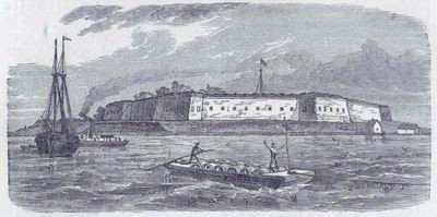 Fort Independence. Directly opposite Fort Independence, as one enters or leaves the inner harbor by the main ship-channel, is the still uncompleted fortification named Fort Winthrop, on Governor’s Island. This island was granted to Governor Winthrop in 1632, and was subsequently confirmed to his heirs. In 1640, the condition was made that he should pay one bushel of apples to the Governor and one to the General Court in winter, annually. It continued in the sole possession of the Winthrop family until 1808, when a part of it was sold to the government for the purpose of erecting a fort, which was named Fort Warren. Subsequently the name Fort Warren was transferred to the fortifications farther down the harbor, and the name of Winthrop given to the work now in process of erection, in honor of the governor and the early owners of the island. When fully completed, Fort Winthrop is intended to be a most important defence to the harbor. 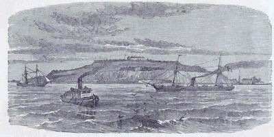 Fort Winthrop. The present Fort Warren is on George’s Island, near the entrance to the harbor, and is the most famous of all the defences of the city. George’s Island was claimed as the property of James Pemberton, of Hull, as early as 1622. His possession of it having been confirmed, it was bought, sold, and inherited by numerous owners, until 1825, when it became the property of the city of Boston. It is now, of course, under the jurisdiction of the United States government. The construction of the present fort was begun in April, 1833, and was completed in 1850. The material is finely hammered Quincy granite, and the stone faces, as well as those parts that have been protected with earth and sodded over, are as neat and trim as art can make them. The fort is one of great strength, but it bus never yet been needed to defend the harbor of Boston. During the Rebellion it was used as a place of confinement for noted Confederate prisoners, the most famous of all being the rebel commissioners to Europe, Mason and Slidel, who were sent here for confinement after their capture on board the Trent by Commodore Wilkes. 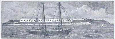 Fort Warren, Boston Harbor. About two miles from Fort Warren, nearly due east, and at the entrance of the harbor, is the Boston Light. The island on which it stands has been used as a lighthouse station since 1715, when the General Court of the colony passed the necessary acts. The land was generously given to the colony by the owners of it, though as there is soil on only about three quarters of an acre, the rest of the two or three acres being bare, jagged rock, the gift entailed no great loss upon them. In the time of the Revolution, the lighthouse was the object of much small warfare, and was several times destroyed and rebuilt. In 1783 it was once more restored by the State, being built this time of stone; and it is this lighthouse which still stands at the mouth of the harbor, though it has since been enlarged and refitted several times. The top of the lighthouse now stands ninety-eight feet above the level of the sea, and is fitted with a revolving light which can be seen from a distance of sixteen nautical miles in fair weather. 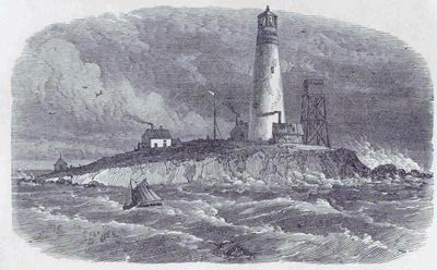 Boston Light. Still nearer to Fort Warren, and on the direct line to Boston Light is the Spit, or Bug Light. It is a curious structure. The lower part is a system of iron pillars fixed in the rock, affording no surface for the waves to beat against and destroy. The fixed red light is about thirty-five feet above the level of the sea, and can be seen at a distance of about seven miles in clear weather. This light was built in 1856. Its object is to warn navigators of the dangerous obstacle known as Harding’s Ledge, about two miles out at sea, east of Point Allerton, at the head of Nantasket Beach. 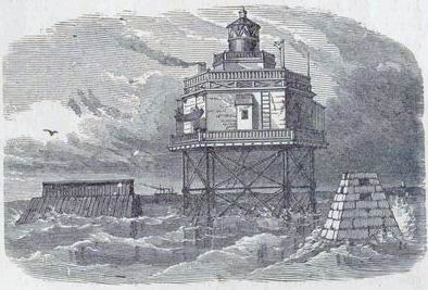 Bug Light. The lighthouse on Long Island was built in 1819. The tower is twenty-two feet in height, but the light is eighty feet above the level of the sea. The tower is of iron, painted white; the lantern has nine burners; the light is fixed, and can be seen in a clear night about fifteen miles. There have been several attempts to make Long Island a place for summer residences. In 1885 it was purchased by the city, and public charitable institutions are to be established upon it. 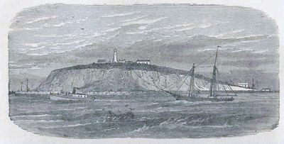 Long Island Light. East of Long Island head there is a low, rocky island on which stands a singularly shaped monument. It consists of a solid structure of stone, twelve feet in height, and forty feet square. All the stones in this piece of masonry are securely fastened together with copper. Upon it stands an octagonal pyramid of wood, twenty feet high, and painted black. It is supposed that this monument was erected in the earliest years of the present century, though the date is not known. Its purpose was to warn vessels of one of the most dangerous shoals in the harbor. This Island is known as Nix’s Mate, though for what reason is not known. There is a tradition, unsupported by facts, that the mate of a vessel of which one Captain Nix was master, was executed upon the island for killing the latter. But it was known as “Nixes Iland,” as long ago as 1636, before any execution for murder or piracy had taken place in the colony, and this would seem to dispose of the story, Several pirates have since been hanged there. One William Fly was hanged there in chains in 1726 for piracy, on which occasion, the Boston News Letter informs us, Fly “behaved himself very unbecomingly, even to the last.” It is a part of the tradition above referred to that Nix’s Mate declared his innocence, and asserted, as a proof of it, that the island would be washed away. If any such prophecy was ever made, it has certainly been fulfilled. We know by the records that it contained in the neighborhood of twelve acres in 1636; there is now not more than one acre of shoal, and there is not a vestige of soil remaining. 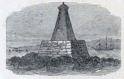 Nix’s Mate. Point Shirley is the southern extremity of the town of Winthrop, but it properly comes into any notice of Boston harbor. Its chief attraction is Taft’s Hotel, noted for its fish and game dinners. Indeed Point Shirley, ever since it received its present name, has been synonymous with good cheer. A company of merchants purchased it in 1753, designing to establish a fishery station. They never put the property to its intended use, but when they were ready to advertise the place, they invited Governor Shirley to go down to the spot with them. He accepted, the party had a fine time and a fine dinner, and by permission of his Excellency, what had before been known as Pulling Point was dubbed Point Shirley. The name of Pulling Point has since been transferred to another point of land on the same peninsula. 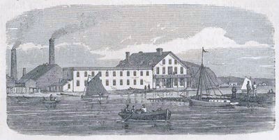 Point Shirley. We have only glanced at the harbor and a few of the numerous places of interest in and about it. The islands in the harbor are many, and of very peculiar shapes, which fact has given some of them their names, — as, for instance, Spectacle, Half Moon, and Apple Islands. Few of them are occupied, and several are uninhabitable, but the sail among and around them is in the summertime a most agreeable change from the hot brick walls and dusty streets of the city. If we extend our view beyond the harbor along the north shore we shall see Revere Beach, — one of the finest on the coast, — Lynn, and Nahant. Both the latter places may easily be visited by steamers. Nahant is perhaps the chief glory of the north shore. It is a peninsula connected with the mainland at Lynn by a long narrow neck, upon which is a noble beach. Those who dwell upon the peninsula regard its comparative inaccessibility as something strongly in its favor. They have not allowed a large hotel to be erected upon it since the destruction by fire of one that formerly stood in the town. Nahant is a favorite resort for picnickers, for whom a place has been specially provided which is fantastically called Maolis Gardens, — Maolis being nothing more than Siloam spelled backwards. For the rest, Nahant is occupied by wealthy citizens of Boston who have erected for themselves in this secluded place elegant summer residences where, in the midst of their gardens and groves and lawns, they may live as freely and quietly as they wish. The sea-view is magnificent. The peninsula lies near to the entrance of Boston Harbor, and is practically an island at some distance from the coast. All the grandeur of the sea in a storm, and all the beauty of the sea on a fine day when the horizon is dotted with the white sails of arriving and departing vessels, the dwellers at Nahant enjoy at their grandest and most beautiful. Beyond Nahant are Egg Rock, a small island still farther than Nahant from the coast; Marblehead Neck and Point, which are rapidly coming into favor as summer resorts; Swampscott, already one of the most fashionable of the coast watering-places; and Cape Ann, with its succession of beautiful sea-side villages, — Beverly Farms, Manchester, Gloucester, Rockport, and Pigeon Cove. On the south coast we may find equally interesting and equally beautiful places. At Hingham, among other objects to be noticed, is the oldest church edifice in the country; and off Cohasset is the famous Minot’s Ledge Lighthouse, a solid stone structure that stands where a former lighthouse was destroyed by a storm some years ago, on one of the most dangerous and most dreaded rocks upon our coast.  |
 to
continue to the
next chapter
to
continue to the
next chapter