Web
and Book design, Web
and Book design, Copyright, Kellscraft Studio 1999-2003 (Return to Web Text-ures) |
Click Here to return to Inca Lands Content Page Click Here to return to previous chapter |
 (HOME) |
|
Web
and Book design, Copyright, Kellscraft Studio 1999-2003 (Return to Web Text-ures) |
Click Here to return to Inca Lands Content Page Click Here to return to previous chapter |
(HOME) |
|
CHAPTER
XII THE FORTRESS OF UITICOS AND THE HOUSE OF THE SUN WHEN the viceroy,
Toledo,
determined to conquer that
last stronghold of the Incas where for thirty-five years they had
defied the
supreme power of Spain, he offered a thousand dollars a year as a
pension to
the soldier who would capture Tupac Amaru. Captain Garcia earned the
pension,
but failed to receive it; the “mañana habit” was already strong in the
days of
Philip II. So the doughty captain filed a collection of testimonials
with
Philip’s Royal Council of the Indies. Among these is his own statement
of what
happened on the campaign against Tupac Amaru. In this he says: “and
having
arrived at the principal fortress, Guaynapucara [“the young fortress”],
which
the Incas had fortified, we found it defended by the Prince Philipe
Quispetutio, a son of the Inca Titu Cusi, with his captains and
soldiers. It is
on a high eminence surrounded with rugged crags and jungles, very
dangerous to
ascend and almost impregnable. Nevertheless, with my aforesaid company
of
soldiers I went up and gained the fortress, but only with the greatest
possible
labor and danger. Thus we gained the province of Uilcapampa.” The
viceroy
himself says this important victory was due to Captain Garcia’s skill
and
courage in storming the heights of Guaynapucara, “on Saint John the
Baptist’s
day, in 1572.” The “Hill of Roses”
is indeed
“a high eminence
surrounded with rugged crags.” The side of easiest approach is
protected by a
splendid, long wall, built so carefully as not to leave a single
toe-hold for
active besiegers. The barracks at Uncapampa could have furnished a
contingent
to make an attack on that side very dangerous. The hill is steep on all
sides,
and it would have been extremely easy for a small force to have
defended it. It
was undoubtedly “almost impregnable.” This was the feature Captain
Garcia was
most likely to remember. On the very summit of the hill are the ruins of a partly enclosed compound consisting of thirteen or fourteen houses arranged so as to form a rough square, with one large and several small courtyards. The outside dimensions of the compound are about 160 feet by 145 feet. The builders showed the familiar Inca sense of symmetry in arranging the houses. Due to the wanton destruction of many buildings by the natives in their efforts at treasure-hunting, the walls have been so pulled down that it is impossible to get the exact dimensions of the buildings. In only one of them could we be sure that there had been any niches.
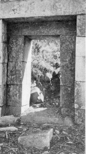
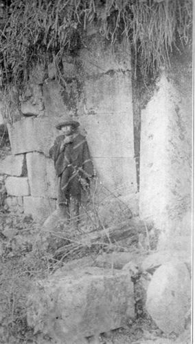
Most interesting of
all is the
structure which
caught the attention of Ocampo and remained fixed in his memory. Enough
remains
of this building to give a good idea of its former grandeur. It was
indeed a
fit residence for a royal Inca, an exile from Cuzco. It is 245 feet by
43 feet.
There were no windows, but it was lighted by thirty doorways, fifteen
in front
and the same in back. It contained ten large rooms, besides three
hallways
running from front to rear. The walls were built rather hastily and are
not
noteworthy, but the principal entrances, namely, those leading to each
hall,
are particularly well made; not, to be sure, of “marble” as Ocampo said
— there
is no marble in the province — but of finely cut ashlars of white
granite. The
lintels of the principal doorways, as well as of the ordinary ones, are
also of
solid blocks of white granite, the largest being as much as eight feet
in
length. The doorways are better than any other ruins in Uilcapampa
except those
of Machu Picchu, thus justifying the mention of them made by Ocampo,
who lived
near here and had time to become thoroughly familiar with their
appearance.
Unfortunately, a very small portion of the edifice was still standing.
Most of
the rear doors had been filled up with ashlars, in order to make a
continuous
fence. Other walls had been built from the ruins, to keep cattle out of
the
cultivated pampa. Rosaspata is at an elevation which
places it on the
borderland between the cold grazing country, with its root crops and
sublimated
pigweeds, and the temperate zone where maize flourishes. On the south side of
the
hilltop, opposite the long
palace, is the ruin of a single structure, 78 feet long and 35 feet
wide,
containing doors on both sides, no niches and no evidence of careful
workmanship.
It was probably a barracks for a company of soldiers. The intervening
“pampa” might
have been the scene of
those games of bowls and quoits, which were played by the Spanish
refugees who
fled from the wrath of Gonzalo Pizarro and found refuge with the Inca
Manco.
Here may have occurred that fatal game when one of the players lost his
temper
and killed his royal host. Our excavations in
1915 yielded
a mass of rough
potsherds, a few Inca whirl-bobs and bronze shawl pins, and also a
number of
iron articles of European origin, heavily rusted — horseshoe nails, a
buckle, a
pair of scissors, several bridle or saddle ornaments, and three
Jew’s-harps. My
first thought was that modern Peruvians must have lived here at one
time,
although the necessity of carrying all water supplies up the hill would
make
this unlikely. Furthermore, the presence here of artifacts of European
origin
does not of itself point to such a conclusion. In the first place, we
know that
Manco was accustomed to make raids on Spanish travelers between Cuzco
and Lima.
He might very easily have brought back with him a Spanish bridle. In
the second
place the musical instruments may have belonged to the refugees, who
might have
enjoyed whiling away their exile with melancholy twanging. In the third
place
the retainers of the Inca probably visited the Spanish market in Cuzco,
where
there would have been displayed at times a considerable assortment of
goods of
European manufacture. Finally Rodriguez de Figueroa speaks expressly of
two
pairs of scissors he brought as a present to Titu Cusi. That no such
array of
European artifacts has been turned up in the excavations of other
important
sites in the province of Uilcapampa would seem to indicate that they
were
abandoned before the Spanish Conquest or else were occupied by natives
who had
no means of accumulating such treasures. Thanks to Ocampo’s
description
of the fortress which
Tupac Amaru was occupying in 1572 there is no doubt that this was the
palace of
the last Inca. Was it also the capital of his brothers, Titu Cusi and
Sayri
Tupac, and his father, Manco? It is astonishing how few details we have
by
which the Uiticos of Manco may be identified. His contemporaries are
strangely
silent. When he left Cuzco and sought refuge “in the remote fastnesses
of the
Andes,” there was a Spanish soldier, Cieza de Leon, in the armies of
Pizarro
who had a genius for seeing and hearing interesting things and writing
them
down, and who tried to interview as many members of the royal family as
he
could; — Manco had thirteen brothers. Cieza de Leon says he was much
disappointed not to be able to talk with Manco himself and his sons,
but they
had “retired into the provinces of Uiticos, which are in the most
retired part
of those regions, beyond the great Cordillera of the Andes.”1
The
Spanish refugees who died as the result of the murder of Manco may not
have
known how to write. Anyhow, so far as we can learn they left no
accounts from
which any one could identify his residence. Titu Cusi gives no
definite clue, but the activities of Friar Marcos and Friar Diego, who
came to
be his spiritual advisers, are fully described by Calancha. It will be
remembered that Calancha remarks that “close to Uiticos in a village
called
Chuquipalpa, is a House of the Sun and in it a white stone over a
spring of
water.” Our guide had told us there was such a place close to the hill
of
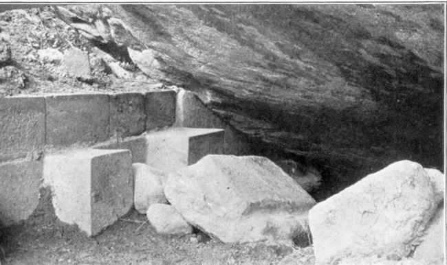
Rosaspata. 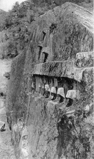 NORTHEAST FACE OF YURAK RUMI On the day after
making the
first studies of the
“Hill of Roses,” I followed the impatient Mogrovejo — whose object was
not to
study ruins but to earn dollars for finding them — and went over the.
hill on
its northeast side to the Valley of Los Andenes (“the
Terraces”). Here, sure enough, was a large, white granite boulder,
flattened on
top, which had a carved seat or platform on its northern side. Its west
side
covered a cave in which were several niches. This cave had been walled
in on
one side. When Mogrovejo and the Indian guide said there was a manantial de agua (“spring of water”)
near by, I became greatly interested. On investigation, however, the
“spring”
turned out to be nothing but part of a small irrigating ditch. (Manantial means “spring”; it also means
“running water”). But the rock was not “over the water.” Although this
was
undoubtedly one of those huacas, or sacred
boulders, selected by the Incas as the visible representations of the
founders
of a tribe and thus was an important accessory to ancestor worship, it
was not
the Yurak Rumi for which we were looking. Leaving the boulder and the
ruins of
what possibly had been the house of its attendant priest, we followed
the
little water course past a large number of very handsomely built
agricultural
terraces, the first we had seen since leaving Machu Picchu and the most
important ones in the valley. So scarce are andenes
in this region and so noteworthy were these in
particular that this vale
has been named after them. They were probably built under the direction
of
Manco. Near them are a number of carved boulders, huacas.
One had an intihuatana,
or sundial nubbin, on it; another was carved in the
shape of a saddle.
Continuing, we followed a trickling stream through thick woods until we
suddenly arrived at an open place called Nusta Isppana. Here before us
was a
great white rock over a spring. Our guides had not misled us. Beneath
the trees
were the ruins of an Inca temple, flanking and partly enclosing the
gigantic
granite boulder, one end of which overhung a small pool of running
water. When
we learned that the present name of this immediate vicinity is
Chuquipalta our
happiness was complete. It was late on the
afternoon of
August 9, 1911, when
I first saw this remarkable shrine. Densely wooded hills rose on every
side.
There was not a hut to be seen; scarcely a sound to be heard. It was an
ideal
place for practicing the mystic ceremonies of an ancient cult. The
remarkable
aspect of this great boulder and the dark pool beneath its shadow had
caused
this to become a place of worship. Here, without doubt, was “the
principal mochadero of those
forested mountains.”
It is still venerated by the Indians of the vicinity. At last we had
found the
place where, in the days of Titu Cusi, the Inca priests faced the east,
greeted
the rising sun, “extended their hands toward it,” and “threw kisses to
it,” “a
ceremony of the most profound resignation and reverence.” We may
imagine the
sun priests, clad in their resplendent robes of office, standing on the
top of
the rock at the edge of its steepest side, their faces lit up with the
rosy
light of the early morning, awaiting the moment when the Great Divinity
should appear
above the eastern hills and receive their adoration. As it rose they
saluted it
and cried: “O Sun! Thou who art in peace and safety, shine upon us,
keep us
from sickness, and keep us in health and safety. O Sun! Thou who hast
said let
there be Cuzco and Tampu, grant that these children may conquer all
other
people. We beseech thee that thy children the Incas may be always
conquerors,
since it is for this that thou hast created them.” It was during Titu
Cusi’s reign
that Friars Marcos
and Diego marched over here with their converts from Puquiura, each
carrying a
stick of firewood. Calancha says the Indians worshiped the water as a
divine
thing, that the Devil had at times shown himself in the water. Since
the
surface of the little pool, as one gazes at it, does not reflect the
sky, but
only the overhanging, dark, mossy rock, the water looks black and
forbidding,
even to unsuperstitious Yankees. It is easy to believe that
simple-minded
Indian worshipers in this secluded spot could readily believe that they
actually saw the Devil appearing “as a visible manifestation” in the
water.
Indians came from the most sequestered villages of the dense forests to
worship
here and to offer gifts and sacrifices. Nevertheless, the Augustinian
monks
here raised the standard of the cross, recited their orisons, and piled
firewood all about the rock and temple. Exorcising the Devil and
calling him by
all the vile names they could think of, the friars commanded him never
to
return. Setting fire to the pile, they burned up the temple, scorched
the rock,
making a powerful impression on the Indians and causing the poor Devil
to flee,
“roaring in a fury.” “The cruel Devil never more returned to the rock
nor to
this district.” Whether the roaring which they heard was that of the
Devil or
of the flames we can only conjecture. Whether the conflagration
temporarily
dried up the swamp or interfered with the arrangements of the water
supply so
that the pool disappeared for the time being and gave the Devil no
chance to
appear in the water, where he had formerly been accustomed to show
himself, is
also a matter for speculation. The buildings of the
House of
the Sun are in a very
ruinous state, but the rock itself, with its curious carvings, is well
preserved notwithstanding the great conflagration of 1570. Its length
is
fifty-two feet, its width thirty feet, and its height above the present
level
of the water, twenty-five feet. On the west side of the rock are seats
and
large steps or platforms. It was customary to kill llamas at these holy huacas. On top of the rock is a
flattened place which may have been used for such sacrifices. From it
runs a
little crack in the boulder, which has been artificially enlarged and
may have
been intended to carry off the blood of the victim killed on top of the
rock.
It is still used for occult ceremonies of obscure origin which are
quietly
practiced here by the more superstitious Indian women of the valley,
possibly
in memory of the Nusta or Inca princess for whom the shrine is named. On the south side of
the
monolith are several large
platforms and four or five small seats which have been cut in the rock.
Great
care was exercised in cutting out the platforms. The edges are very
nearly
square, level, and straight. The east side of the rock projects over
the spring.
Two seats have been carved immediately above the water. On the north
side there
are no seats. Near the water, steps have been carved. There is one
flight of
three and another of seven steps. Above them the rock has been
flattened
artificially and carved into a very bold relief. There are ten
projecting
square stones, like those usually called intihuatana
or “places to which the sun is tied.” In one line are
seven; one is
slightly apart from the six others. The other three are arranged in a
triangular position above the seven. It is significant that these
stones are on
the northeast face of the rock, where they are exposed to the rising
sun and
cause striking shadows at sunrise.
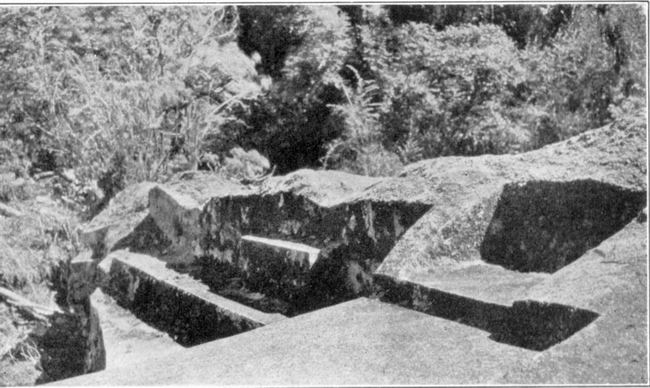
 TWO OF THE SEVEN SEATS NEAR THE SPRING UNDER THE GREAT WHITE ROCK Our excavations
yielded no
artifacts whatever and
only a handful of very rough old potsherds of uncertain origin. The
running
water under the rock was clear and appeared to be a spring, but when we
drained
the swamp which adjoins the great rock on its northeastern side, we
found that
the spring was a little higher up the hill and that the water ran
through the
dark pool. We also found that what looked like a stone culvert on the
borders
of the little pool proved to be the top of the back of a row of seven
or eight
very fine stone seats. The platform on which the seats rested and the
seats
themselves are parts of three or four large rocks nicely fitted
together. Some
of the seats are under the black shadows of the overhanging rock. Since
the
pool was an object of fear and mystery the seats were probably used
only by
priests or sorcerers. It would have been a splendid place to practice
divination. No doubt the devils “roared.” All our expeditions
in the
ancient province of
Uilcapampa have failed to disclose the presence of any other “white
rock over a
spring of water” surrounded by the ruins of a possible “House of the
Sun.”
Consequently it seems reasonable to adopt the following conclusions: First,
Nusta Isppana is the Yurak Rumi of Father Calancha. The Chuquipalta of
to-day
is the place to which he refers as Chuquipalpa. Second,
Uiticos, “close to” this shrine, was once the name of
the
present valley of Vilcabamba between Tincochaca and Lucma. This is the
“Viticos” of Cieza de Leon, a contemporary of Manco, who says that it
was to
the province of Viticos that Manco determined to retire when he
rebelled
against Pizarro, and that “having reached Viticos with a great quantity
of
treasure collected from various parts, together with his women and
retinue, the
king, Manco Inca, established himself in the strongest place he could
find, whence
he sallied forth many times and in many directions and disturbed those
parts
which were quiet, to do what harm he could to the Spaniards, whom he
considered
as cruel enemies.” Third, the
“strongest place” of Cieza, the Guaynapucara of Garcia, was Rosaspata,
referred
to by Ocampo as “the fortress of Pitcos,” where, he says, “there was a
level
space with majestic buildings,” the most noteworthy feature of which
was that
they had two kinds of doors and both kinds had white stone lintels. Fourth, the modern village of Pucyura in
the valley of the river Vilcabamba is the Puquiura of Father Calancha,
the site
of the first mission church in this region, as assumed by Raimondi,
although he
was disappointed in the insignificance of the “wretched little
village.” The
remains of the old quartz-crushing plant in Tincochaca, which has
already been
noted, the distance from the “House of the Sun,” not too great for the
religious procession, and the location of Pucyura near the fortress,
all point
to the correctness of this conclusion. Finally, Calancha
says that
Friar Ortiz, after he
had secured permission from Titu Cusi to establish the second
missionary
station in Uilcapampa, selected “the town of Huarancalla, which was
populous
and well located in the midst of a number of other little towns and
villages.
There was a distance of two or three days’ journey from one convent to
the
other. Leaving Friar Marcos in Puquiura, Friar Diego went to his new
establishment, and in a short dine built a church.” There is no
“Huarancalla”
to-day, nor any tradition of any, but in Mapillo, a pleasant valley at
an
elevation of about 10,000 feet, in the temperate zone where the crops
with
which the Incas were familiar might have been raised, near pastures
where
llamas and alpacas could have flourished, is a place called
Huarancalque The
valley is populous and contains a number of little towns and villages.
Furthermore, Huarancalque is two or three days’ journey from Pucyura
and is on
the road which the Indians of this region now use in going to Ayacucho.
This
was undoubtedly the route used by Manco in his raids on Spanish
caravans. The
Mapillo flows into the Apurimac near the mouth of the river Pampas. Not
far up
the Pampas is the important bridge between Bombon and Ocros, which Mr.
Hay and
I crossed in 1909 on our way from Cuzco to Lima. The city of Ayacucho
was
founded by Pizarro, a day’s journey from this bridge. The necessity for
the
Spanish caravans to cross the river Pampas at this point made it easy
for
Manco’s foraging expeditions to reach them by sudden marches from
Uiticos down
the Mapillo River by way of Huarancalque, which is probably the
“Huarancalla”
of Calancha’s “Chronicles.” He must have had rafts or canoes on which
to cross
the Apurimac, which is here very wide and deep. In the valleys between
Huarancalque and Lucma, Manco was cut off from central Peru by the
Apurimac and
its magnificent canyon, which in many places has a depth of over two
miles. He
was cut off from Cuzco by the inhospitable snow fields and glaciers of
Salcantay,
Soray, and the adjacent ridges, even though they are only fifty miles
from
Cuzco. Frequently all the passes are completely snow-blocked.
Fatalities have
been known even in recent years. In this mountainous province Manco
could be
sure of finding not only security from his Spanish enemies, but any
climate
that he desired and an abundance of food for his followers. There seems
to be
no reason to doubt that the retired region around the modern town of
Pucyura in
the upper Vilcabamba Valley was once called Uiticos. __________________
1 In
those days the term “Andes” appears to have been very limited in scope,
and was
applied only to the high range north of Cuzco where lived the tribe
called
Antis. Their name was given to the range. Its culminating point was Mt.
Salcantay. Click
 here to continue to the next chapter of Inca Lands
|